Comté de Livingston (Michigan)
| Comté de Livingston | |
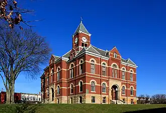 Palais de justice du comté de Livingston à Howell | |
| Administration | |
|---|---|
| Pays |  États-Unis États-Unis
|
| État |  Michigan Michigan
|
| Chef-lieu | Howell |
| Fondation | 1836 |
| Démographie | |
| Population | 193 866 hab. (2020) |
| Densité | 132 hab./km2 |
| Géographie | |
| Coordonnées | 42° 36′ nord, 83° 55′ ouest |
| Superficie | 147 200 ha = 1 472 km2 |
| Superficie eau | 4 400 ha = 44 km2 |
| Superficie totale | 151 600 ha = 1 516 km2 |
| Localisation | |
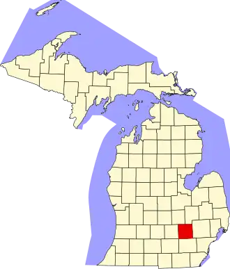 Localisation du comté dans l'État. | |
Le comté de Livingston (Livingston County en anglais) est un comté dans le sud-est de la péninsule inférieure de l'État du Michigan. Son siège est à Howell. Selon le recensement de 2020, sa population est de 193 866 habitants.
Géographie
Le comté a une superficie de 1 516 km², dont 1 472 km² est de terre.
Comtés adjacents
- Comté de Genesee (nord-est)
- Comté de Shiawassee (nord-ouest)
- Comté de Washtenaw (sud)
- Comté d'Oakland (est)
- Comté d'Ingham (ouest)
- Comté de Jackson (sud-est)
Démographie
| Historique des recensements | |||
| Année | Pop. | %± | |
|---|---|---|---|
| 1840 | 7 430 | — | |
| 1850 | 13 485 | ▲ +81,49 % | |
| 1860 | 16 851 | ▲ +24,96 % | |
| 1870 | 19 336 | ▲ +14,75 % | |
| 1880 | 22 251 | ▲ +15,08 % | |
| 1890 | 20 858 | ▼ −6,26 % | |
| 1900 | 19 664 | ▼ −5,72 % | |
| 1910 | 17 736 | ▼ −9,8 % | |
| 1920 | 17 522 | ▼ −1,21 % | |
| 1930 | 19 274 | ▲ +10 % | |
| 1940 | 20 863 | ▲ +8,24 % | |
| 1950 | 26 725 | ▲ +28,1 % | |
| 1960 | 38 233 | ▲ +43,06 % | |
| 1970 | 58 967 | ▲ +54,23 % | |
| 1980 | 100 289 | ▲ +70,08 % | |
| 1990 | 115 645 | ▲ +15,31 % | |
| 2000 | 156 951 | ▲ +35,72 % | |
| 2010 | 180 967 | ▲ +15,3 % | |
| 2020 | 193 866 | ▲ +7,13 % | |
Liens externes
- (en) Site officiel
- Ressource relative à la géographie :
- Ressource relative à la musique :
- Portail du Michigan